| The Itinerary | The Participants | General Information | Pre-Trip Workparty July 1-8 |
Equipment List | Volunteer Opportunities | History of the Wonderland Trail | Tales of Other Hikers |
Wonderland Trail History

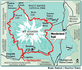
Built in 1915, the famous 93-mile footpath occupies a route where engineers in the 1930s envisioned a paved "Wonderland Highway" to circle the Mountain. The trail constantly traverses Mount Rainier's dozens of lava-formed ridgelines, resulting in few level portions along the route. A hiker who completes the trail will have amassed a cumulative elevation gain of more than 20,000 feet, nearly 6,000 feet higher than the mountain. The trail's low point is located where it crosses Ipsut Creek in the park's northwest corner, just below 3,000 feet. Twice the trail ascends to 7,000 feet - at Panhandle Gap on the Mountain's east side (between Summerland and Indian Bar) and at Skyscraper Pass on the north side, about four miles west of Sunrise